Back منطقة حمراء (بعد الحرب) Arabic Zone rouge German Zona roja (secuelas bélicas) Spanish Zone rouge (séquelles de guerre) French אזורים אדומים HE Ebe uhie IG Zone Rouge Italian ゾーン・ルージュ Japanese 존 루주 Korean സോൺ റൂജ് Malayalam
You can help expand this article with text translated from the corresponding article in French. (June 2012) Click [show] for important translation instructions.
|
50°22′N 2°48′E / 50.36°N 2.80°E


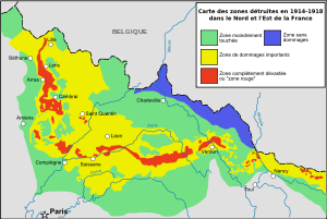
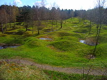
The zone rouge (English: red zone) is a chain of non-contiguous areas throughout northeastern France that the French government isolated after the First World War. The land, which originally covered more than 1,200 square kilometres (460 square miles), was deemed too physically and environmentally damaged by conflict for human habitation. Rather than attempt to immediately clean up the former battlefields, the land was allowed to return to nature. Restrictions within the Zone Rouge still exist today, although the control areas have been greatly reduced.
The zone rouge was defined just after the war as "Completely devastated. Damage to properties: 100%. Damage to Agriculture: 100%. Impossible to clean. Human life impossible".[1]
Under French law, activities such as housing, farming, or forestry were temporarily or permanently forbidden in the Zone Rouge, because of the vast amounts of human and animal remains, and millions of items of unexploded ordnance contaminating the land. Some towns and villages were never permitted to be rebuilt after the war.
© MMXXIII Rich X Search. We shall prevail. All rights reserved. Rich X Search